![]()
![]()
![]()
![]()
![]()
![]()
![]()
![]()
|
|
|
|
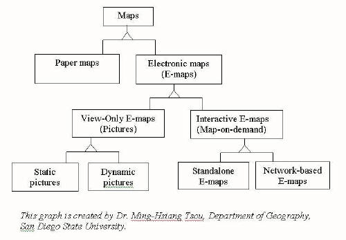
First, electronic maps (E-maps) can create view-only E-maps (picture) and interactive maps (map-on-demand). For view-only E-maps as static maps/dynamic pictures, map viewers cannot modify map designs and formats. For interactive maps such as standalone E-maps/network-based E-maps, in contrast, map viewers can modify the map designs and formats through use of programs such as ArcGIS (standalone E-map) and Google Map (network-based E-maps).
Source: http://map.sdsu.edu/geog583/lecture/Unit-3.htm (GEO G583 Internet Mapping and Distributed GIServices)
We hope, you like our interactive map instead of the view-only E-map. Enjoy!
ArcGIS Server Manager Today, there are many types of interactive maps, including ArcGIS and Google Map. First, we questioned ourselves about the user interface for mapping on our internet mapping project: Who are our users? What kinds of services do we provide on our website? We selected ArcGIS Server Manager for our website to display places for farmers' markets and farm stands because of a comprehensive use of GIS functions and tools.
What is ArcGIS Server Manager? ArcGIS Server Manager of ESRI helps to manage geographical information for use throughout an organization or through the Internet. With this platform, people can publish and share the GIS resources with others through the organization's network or an Internet community while using the ArcGIS Desktop at a local desk or across the world. The geographical information will be stored on a server for users to access and store their most up-to-date information. The platform also provides web applications and web services for users who want access through a web browser. Users will be able to view and change some functions without the need ArcGIS Desktop. For more information about ArcGIS Server, please visit website: ArcGIS Server Help.
Please click here to use our map. Have fun!
Please click here to see explanation about our interactive map.
|
|
Send mail to
bilbo1usa@yahoo.com with
questions or comments about this web site.
|
 On our
interactive map, you can change the viewing options for user interfaces on
the map
such as changing layers, selecting feature, and identifying features for our
map. We focus to provide on our interactive map an attractive interface for map users
with features that are "interactive" and "multimedia." We believe that
a simple/easy,
entertaining, and fun map would attract a variety of skill level users learning
to process the
information.
On our
interactive map, you can change the viewing options for user interfaces on
the map
such as changing layers, selecting feature, and identifying features for our
map. We focus to provide on our interactive map an attractive interface for map users
with features that are "interactive" and "multimedia." We believe that
a simple/easy,
entertaining, and fun map would attract a variety of skill level users learning
to process the
information.