![]()
![]()
![]()
![]()
|
|
|
|
About database Here are the resources that we used for the database based on importance to the map images, impact on local transportation, and local farming methods and practices. With some of the data, we used geocoding to locate the addresses of the farmer's markets and farm stands through ArcGIS. We use resources (World Imagery, World Street Map, and US Topo Maps) from ArcGIS Resource Centers which are ArcGIS Online Services from ESRI for high-resolution maps and variety of information.
We use resources (Railroads and Transit Routes) from SANDAG which the 18 cities and county government are San Diego Association of Government (SANDAG) serving as the forum for regional decision-making.
We use resources (farmers' markets and farm stands) from San Diego County Farm Bureau which is a non-profit organization in San Diego county and one of the 53 county Farm Bureau in California.
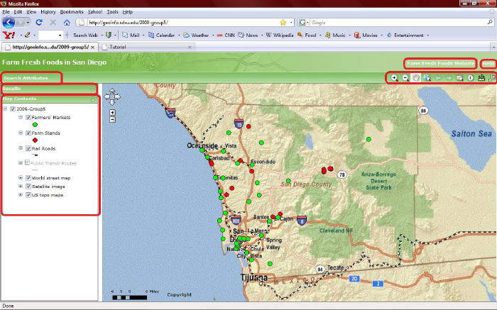
About our map Here is our interactive map, "Farm Fresh Foods in San Diego," through ArcGIS Server Manager of ESRI. The Web mapping application can provide various levels of use to find useful geospatial information about farmers' market and farm stands, and to explore the entire San Diego areas.
The application consists of a map display area and menu/toolbar on the top of border. The menu include "search attribute," "this website link," and "help." The toolbar includes "zoom in/out," "pan," "previous/next extent," "zoom to full extent," "identify," and "measure distance and area." On the left side of the map display area, it also consists of results, results' details, and map contents as layer list, navigation, and map overview which users can choose open/close and pop up window on the map. We hope, our internet mapping functions display great visualization for providing information on the map. You may like it!
Unfortunately, we have some potential problems on our map and still haven't fix yet even though Dr. Ming helped to fix those problems. One of the potential reason, it may connect to ESRI resources on our map that may not accept to manage/alter their default setting by individual mapping creator. On tutorial page, you can see our potential problems on our map.
For more details about ArcGIS Sever Manager, please click websites: Web Mapping Application Help and ESRI Support Center.
Please click here to use our map. Have fun!
Please click here to learn about tutorial for our map.
|
|
Send mail to
bilbo1usa@yahoo.com with
questions or comments about this web site.
|