High School GIS Awareness
Learning Module 1: Mapping Earthquake Magnitude & Plate
Boundaries with ArcExplorer Java Edition for Education
A Scalable Skills Certification Program in GIS
National Science Foundation-Advanced Technological Education
Division of Undergraduate Education (NSF-ATE DUE) Research Grant #0401990

http://geoinfo.sdsu.edu/hightech
This GIS learning module is developed through a National Science Foundation – Advanced
Technological Education Program Division of Undergraduate Education Research Grant (NSF-ATE
DUE # 0401990): “A Scalable Skills Certification Program in Geographic Information Systems (GIS)”.
This project is a collaborative research partnership between San Diego Mesa College, San Diego
State University, San Diego City Schools, and members of the local community. Please explore our
research Website to learn more about our research and programs.
http://geoinfo.sdsu.edu/hightech
Outline of this Document
1. GIS Learning Module Summary
2. Introduction to this GIS Learning Module
3. GIS Learning Module Audience
7. Description of the Research Project
8. Comments, Suggestions, and Inquiries
9. Disclaimer
10. Contacts
11. GIS Learning Module 1: Earthquake Chasers
Section 1, Section 2, Section 3, Earthquake Quiz, Quiz Answers
Click here to link to the Earthquake Interactive GIS map.
http://geoinfo.sdsu.edu/website/SanFrancisco
Education Category
High School Earth Science Education
Grade Level
9th to 12th Grades
Learning Module Objective
The intention of this learning module is to introduce some GIS technology and features to high
school-age students through the use of an earth science/physical science learning module on
earthquakes/seismology/plate tectonics.
In this module, the student will make a map showing earthquake locations, color classify them
based on earthquake magnitude, and identify plate boundaries. In these activities, the student
will develop an understanding of the relationships between earthquakes and plate tectonic
boundaries.
A major portion of this learning module is completed with the free ESRI, Inc. GIS software
package, “ArcExplorer Java Edition for Education” and associated learning module data.
Instructions for obtaining the requisite software and data are given below.
Learning Level
· Earth Science: Introductory
· GIS: Introductory
Required Materials-Computer Hardware
· Compatible Platforms:
- Windows 98
- Windows 98SE
- Windows 2000
- Windows NT
- Windows XP
- Macintosh OS-X (or newer)
· Minimum Recommended Configuration:
- 250 MB Hard Drive Space Available
- 16MB RAM
- 2MB Video Memory
- Color VGA Monitor
- Keyboard
- Mouse
- Connection to the Internet (for initial software download, data download, and certain
learning activities only)
Required Materials-Computer Software
Free Software:
ESRI ArcExplorer Java Edition for Education (AEJEE)
(Instructions for obtaining AEJEE are given below.)
Compatible Platforms:
WIN: Windows 98, Windows 98SE, Windows 2000, Windows NT, Windows XP
MAC: Apple Macintosh OS-X or newer
Required Materials-Learning Module Data
“seismic.zip” from ESRI K-12 Educational ArcLessons (author: Bob Coulter)
Files used in the “seismic.zip” ZIP archive file include the following:
· “country.shp”
· “plate_in.shp”
· “quak2000.txt”
Bob Coulter <bob.coulter@mobot.org> of the Missouri Botanical Gardens is the author of the original data files and lesson from which this GIS learning module was derived.
(Note: Actual file names do not include quotation marks.)
Optional Materials-Reference Reading
Earthquake Intensity (Richter Magnitude Scale) Information from the Ministry of Energy and Mines in the Province of British Columbia, Canada
http://www.em.gov.bc.ca/Mining/Geolsurv/Surficial/quake/eq2.htm
Education Content Standards
This GIS learning module follows content standards specified by the California State Board of
Education (http://www.cde.ca.gov/be/st/ss/scearth.asp).
The following topical areas are specifically covered in this learning module:
Grades Nine through Twelve - Earth Science
Dynamic Earth Processes
3. Plate tectonics operating over geologic time has changed the patterns of land,
sea, and mountains on Earth's surface. As the basis for understanding this
concept:
a. Students know features of the ocean floor (magnetic patterns, age,
and sea-floor topography) provide evidence of plate tectonics.
d. Students know why and how earthquakes occur and the scales
used to measure their intensity and magnitude.
California Geology
9. The geology of California underlines the state’s wealth of natural resources as
well as its natural hazards. As a basis for understanding the concept:
b. Students know the principle natural hazards in different California
regions and the geologic basis of those hazards.
Learning Objectives
Upon completion of this activity, students will learn about the following concepts:
§ Earthquake/Seismology Concepts:
- Be able to identify world earthquake locations.
- Be able to comprehend the Richter Magnitude Scale.
-
Be able to explain the relationship between earthquakes and plate tectonic
boundaries.
§ ArcExplorer Java Edition for Education GIS Skills/Concepts:
- Be able to add data and change layer properties.
- Be able to change the layers of view.
- Be able to add themes and change theme properties.
- Be able to construct a map query with a query builder.
- Be able to overlay maps and identify spatial relationships.
Estimated time for Learning Module Completion
The learning module may be broken up into 3 sections. Each section will likely require 15~30
minutes of activity time with a total of 60 minutes. These sections are readily identifiable.
Note to Educator, Instructor, or Learning Module Participant
To participate in this activity, you will first need to have the requisite hardware, software, and data as
given by this document. Instructions for obtaining and setting up the software and data are given in
this document.
Depending on the comfort level of the learning module participant, they may need assistance in
setting up and participating in some or all of this learning activity. In general, the intended audience
should be able to complete this module with minimal guidance.
This document, combined with the specified free software and data is an educational product of the
NSF-ATE project, “A Scalable Skills Certification Program in GIS.”
The intention of this learning module is to introduce some GIS technology and features to high
school-age students through the use of an earth science/physical science learning module on earthquakes/seismology.
A standard desktop computer, including mouse, monitor, and keyboard is required for this learning
module. To download the application software and data for this learning module, an Internet
connection will also be required. Once the relevant software and data are obtained, the user will no
longer be required to be connected to the Internet unless he/she would like to participate in some
optional learning activities.
This learning module is intended for high school level students (9th through 12th grades). Generally,
this learning module is presented with guidance from an educator, parent, or community member.
Besides offering an introduction to Geographic Information Systems (GIS), this learning module
addresses certain educational content standards provided by the California State Board of Education.
This information was provided in Education Content Standards in the GIS Learning Module Summary
above.
The GIS data is viewed, manipulated, and analyzed in the learning module with a freely available GIS
application from ESRI, Inc. called ArcExplorer Java Edition for Education. The software (and the GIS
data used in the learning module) are compatible with most desktop computer platforms.
Compatible Platforms:
WIN: Windows 98, Windows 98SE, Windows 2000, Windows NT, Windows XP
MAC: Apple Macintosh OS-X or newer
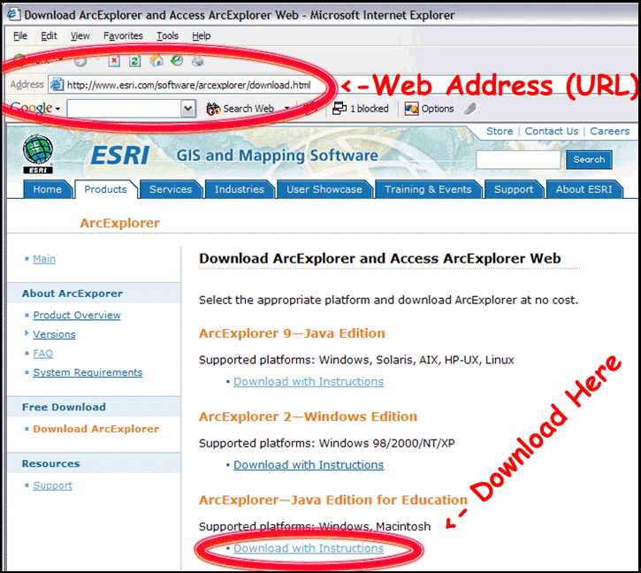
FIGURE A: Download of ESRI ArcExplorer Java Edition for Education (AEJEE)
The user will need to obtain this software application in order to complete the GIS learning module. It
is recommended that the educator, computer system administrator, or an adult complete this step for
younger or less-experienced participants. Here is the download location with Installation Instructions:
http://www.esri.com/software/arcexplorer/download.html
(Note: ArcExplorer Java Edition for Education must be downloaded and installed before the
learning module may be begun.)
While connected to the Internet, copy and paste the Web address to access the download page; then
click on the “Download with Instructions” link for ArcExplorer-Java Edition for Education (FIGURE A).
Follow the instructions to install the application for your platform.
The user will need to obtain data in order to complete the GIS learning module. It is recommended
that the educator, computer system administrator, or an adult complete this step for younger or less-
experienced participants.
This section is separated into two different sets of instruction. The first set of instructions is for users
of a Windows-based platform. The second set of instructions is for users of a Mac-based platform.
Follow the appropriate set of instructions in order to prepare the data for use in the learning module.
This GIS learning module cannot be completed without completing this step.
Windows Users Instructions
You will be downloading a single ZIP (compressed “archive” file) containing the necessary data files
for this GIS learning module.
While connected the Internet, open your Web browser and navigate to the following Website: http://gis.esri.com/industries/education/arclessons/search_results.cfm?topicSearch=Physical%2FEarth%20Sciences
It is best to copy and paste this entire Web address (URL) into the Web address field of your
browser (FIGURE B).
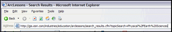
FIGURE B: NAVIGATING TO THE WEBSITE WITH THE MODULE DATA
-
Once the ArcLessons Website has loaded, scroll down (use the “down arrow” on your
keyboard) to almost the end of the Web page and locate the “seismic.zip” file name (FIGURE C).
3. Once you have located the file name, click on the clipboard icon on the left to begin
the download (FIGURE C). The icon is labeled, “Mapping Seismic Activity With ArcView GIS 3.x.”
4. Read and accept the ESRI License agreement and the download of the seismic.zip file should
commence. Be sure to save the download and note its location on your computer.
You will need to know where this file has been saved on your computer. On some computers,
there is a default “Downloads” or “My Documents” or “My Downloads” folder where
downloaded files are saved. If you are given an option on the location where the download will
occur, choose your “Desktop” where it will be easy to find. Consult with your operating
system’s documentation if you have any questions.
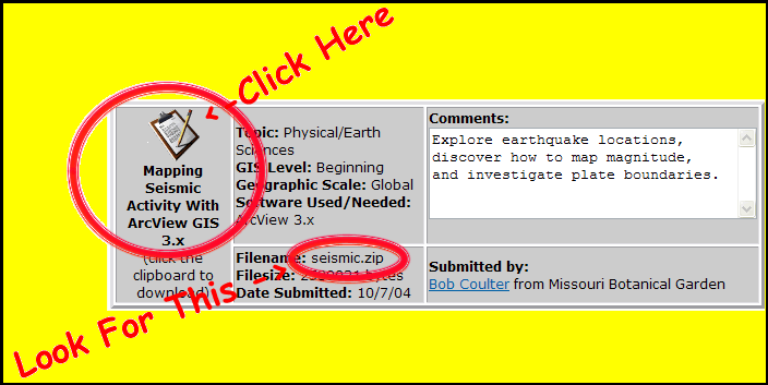
FIGURE C: LOCATING & DOWNLOADING THE REQUIRED DATA FILE
-
After download is complete, you should be able to find the file seismic.zip. As stated before, it
is a compressed ZIP archive containing all of the data files that you will require for this learning
module.
6. Double click the seismic.zip file. If you are lucky, this will launch your ZIP-compatible
decompression utility automatically. If this is not the case, you will need to separately
download a ZIP utility.
There are many compatible ZIP utility applications available. If you don’t have one, you can
download a functional free trial version of WinZip at this Web address:
http://www.winzip.com/downwzeval.htm. (We are sorry but we do not support the installation
and use of a ZIP utility however, we believe that these instructions are sufficient for success. If
you need additional help on decompressing ZIP archives, please consult the help menu
of your ZIP utility application)
7. "Extract" the compressed files from the seismic.zip archive using the “extract” function with
your ZIP utility. This will usually open an extract dialog box showing you the compressed files
and providing you options on the location of these files after they are decompressed.
8. Extract these files to a location where you can find them later. Again, your “Desktop” is a place
where they would be easy to find.
9. If necessary, after decompressing and verifying the presence of the files, you may close your
ZIP utility by choosing the “File” pull-down followed by “Exit.”
Macintosh Users Instructions
You will be downloading a single ZIP (compressed “archive” file) containing the necessary data files
for this GIS learning module.
- While connected the Internet, open your Web browser and navigate to the following Website: http://gis.esri.com/industries/education/arclessons/search_results.cfm?topicSearch=Physical%2FEarth%20Sciences
It is best to copy and paste this entire Web address (URL) into the Web address field of your
browser (FIGURE D).

FIGURE B: NAVIGATING TO THE WEBSITE WITH THE MODULE DATA
2. Once the ArcLessons Website has loaded, scroll down (use the “down arrow” on your
keyboard) to almost the end of the Web page and locate the “seismic.zip” file name (FIGURE E).
3. Once you have located the file name, click on the clipboard icon on the left to begin the
download (FIGURE E). The icon is labeled, “Mapping Seismic Activity With ArcView GIS 3.x.”
4. Read and accept the ESRI License agreement and the download of the seismic.zip file should
commence. Be sure to save the download and note its location on your computer.
You will need to know where this file has been saved on your computer. On some computers,
there is a default “Downloads” or “My Documents” or “My Downloads” folder where
downloaded files are saved. If you are given an option on the location where the download will
occur, choose your “Desktop” where it will be easy to find. Consult with your operating
system’s documentation if you have any questions.
FIGURE E: LOCATING & DOWNLOADING THE REQUIRED DATA FILE
5. After download is complete, you should be able to find the file seismic.zip. As stated before, it
is a compressed ZIP archive containing all of the data files that you will require for this learning module.
6. Start “Stuffit Expander.” If you do not have this application, you will need to separately
download a ZIP utility.
There are many compatible ZIP utility applications available. A functional limited use version
of “Stuffit Expander” is available as a free download at the following Web address:
http://www.stuffit.com/mac/expander/index.html. (We are sorry but we do not support the
installation and use of a ZIP utility however, we believe that these instructions are sufficient for
success. If you need additional help on decompressing ZIP archives, please consult the help
menu of your ZIP utility application)
7. "Expand" the compressed files from the seismic.zip archive using the “Expand” function with
your ZIP utility. The function is usually available in the “File” menu. This will usually open a
dialog box. Locate and select the seismic.zip archive and click the “Expand” button. This will
expand the compressed files to the same directory/location as the original seismic.zip archive.
8. If necessary, after decompressing and verifying the presence of the files, you may close your
ZIP utility by choosing the “File” pull-down followed by “Exit.”
Geographic Information Systems or GIS are the technological tools to store, query, analyze, and
visualize spatially-associated data.
It is an area of phenomenal growth. Applications of GIS exist in almost every level of industry and
government. Some applications include resource management, fleet asset tracking, mapping and
maintenance of networks and grids, sales and market analysis, and environmental monitoring. New
uses for GIS are always being developed and its usage is becoming increasingly widespread. In fact,
if you have used a computer-based, Internet-based, or GPS-based map, you have probably used a
simple GIS tool!
With the expansion of GIS's utilization, there is and will continue to be a significant shortage of trained
and talented people to envision, implement, and operate the future applications of GIS.
With the cooperation and support of the National Science Foundation's Advanced Technological
Education program, San Diego Mesa College, San Diego State University, the San Diego City School
District, GIS industry leaders, and community members this project and program was proposed to
address this great need by preparing motivated individuals for a rewarding career in GIS with the
fundamental knowledge and skills to succeed.
Read more about GIS at our project Website: http://geoinfo.sdsu.edu/hightech.
A major goal of this new project includes facilitating and articulating a comprehensive program of GIS
education for students in the high school, junior college, and 4-year college levels.
This project is one of many initiatives to foster a technologically-literate 21st Century labor force. GIS
usage continues to expand at a significant pace in all sectors of industry and government.
Correspondingly, there is a current and growing need for GIS technicians and GIS education/training.
Ultimately, this program was funded to address these needs.
To learn more about the project and research-related activities, please visit our Research page on the
project Website. To learn more about the anticipated and significant labor shortfall of skilled-and-trained
GIS technicians, please visit our What is GIS? page and click on “Why is GIS Valuable?” on
the project Website. The project Website is accessible at http://geoinfo.sdsu.edu/hightech.
If you have any comments or suggestions for this learning module module, our project Website, or
our research, please contact any of the individuals at the end of this guide or at our Contacts page on
the project Website. We greatly appreciate your input!
Additionally, please let us know if you are interested in participating in our research in any way. We
are especially interested in collaborating with high school students and educators.
The project research team, our sponsoring organizations and institutions, and our affiliates are not
responsible for any errors, omissions, or misrepresentations on the learning module modules or
project Website. If you come across anything that you have questions or concerns about, please let
us know through your comments or suggestions so we can promptly address the matter. Thank you
for your assistance.
John Johnson Ming-Hsiang
(Ming) Tsou, Ph.D.
Principal Investigator Co-PI
A Scalable Skills Certification Program in GIS A Scalable Skills
Certification Program in GIS
San Diego Mesa College Assistant
Professor
7250 Mesa College Dr. Geography
Department
San Diego, CA 92111 San Diego
State University
San Diego, CA 92182
TELEPHONE: 1 619 388 2277
TELEPHONE2: 1 760 635 9409 TELEPHONE: 1 619
594 0205
FAX : 1 760 634 7946 TELEPHONE:
1 619 594 0205
EMAIL : jjohnson@sdccd.net
EMAIL : mtsou@mail.sdsu.edu
Carl Eckberg, Ph.D. Bill
Berggren
Co-PI School
to Career Specialist
A Scalable Skills Certification Program in GIS A Scalable Skills
Certification Program in GIS
Associate Professor School to
Career Transition Team
Computer Science Department San Diego Unified
School District
San Diego State University 2441
Cardinal Lane
5500 Campanile Drive San Diego,
CA 92123
San Diego, CA 92182
TELEPHONE:
1 858 496 1853
TELEPHONE: 1 619 594 6834 FAX : 1 858 496
8129
FAX : 1 619 594 6746 EMAIL : bbergere@mail.sandi.net
EMAIL : eckberg@cs.sdsu.edu