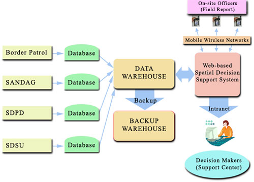

The major tasks of this project includes the adoption of very high resolution (VHR) remotely sensed data, image-derived maps of vegetation conditions, GIS model development and web-based spatial decision support systems. Two data warehouses (one operational and one for emergency backup) will be established to provide the gateway for accessing geo-spatial data and remote sensed imagery for various applications. Each data warehouse will update their data automatically by communicating with each local database server through standardized communication protocol (Z39.50, TCP/IP, and HTTP) and OpenGIS catalog interface. The web-based SDSS will be based on ESRI’s ArcIMS (which includes OGC WMS connector) with ER Mapper’s Image Web Server to provide on-line mapping functions and the display of remotely sensed data. The web-based SDSS will be used by decision makers and spatial analysts in command and control centers to collect and process information via a secure intranet or encrypted mobile wireless networks, to make decisions and initiate responses to field locations and on-site officers.
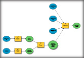
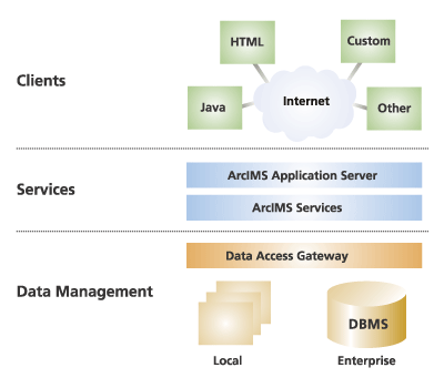
A web-based GIS developed as a component of the SDSS will enable on-line map display, spatial query, and spatial analysis for homeland security tasks. The key component of the web-based GIS is the implementation of Internet Map Servers (ArcIMS), with three-tier software architecture. The first tier is the client component, which includes the user-side web browser and Java-based user interface. The second tier is the middleware which includes the web server and the map engine connector to provide the communication channels between Java clients and map servers. The third tier is the map servers and data storage units that will generate geo-spatial information and maps upon client’s requests. The three-tier software architecture of web-based GIS will provide customizable functions for different mapping applications and scalable implementation for different hardware.
One technological goal of this project is to develop integrated mobile geo-spatial information services that will support and help optimize field-based management tasks for border security agents. The mobile units will utilize state-of-the-art mobile GIS application software (ArcPad 6.0 and ArcPad application builder), global positional systems (GPS), and wireless networking technologies (IEEE 802.11b, Wi-Fi standard) to provide wireless access of large volumes of geo-spatial information and remotely sensed data. Border security agents will access the Internet map servers via their mobile devices and submit the field reports in real time. The actual implementation of mobile units will focus on the customization of software user interface for actual field work and the feasibility testing of hardware/software integration.
The SDSS will be designed and developed to operate at two levels: short-term, operational decision support level and longer-term, tactical decision support level. At the operational level the SDSS will provide functional capabilities to quickly integrate image-derived and GIS data with human judgments. The operational decision support functions will utilize deterministic, fuzzy, and probabilistic multiple criteria decision methods suitable for spatial and non-spatial data. At the tactical level the SDSS will provide tools to generate and evaluate plausible decision scenarios. The architecture of SDSS will be based on interoperable Web services using XML-based technologies and Open GIS Consortium’s geoprocessing specifications. These specifications will allow both wired and wireless access to decision support services using spatially enhanced interfaces. Such architecture will allow the access and use of decision support tools from various locations at any time. The analytical functions of SDSS will adopt Java programming tools to create a series of Java applets for spatial analyses and image-based change detection functions. These Java applets will be organized into a spatial analysis and modeling toolbox, where users will interactively launch individual analytical functions. The SDSS will enable better management decisions such as agent deployment, improving humanitarian rescue/recover operations, and facilitating multi-agency coordination.