
|
|

The Architecture of Mobile GIS
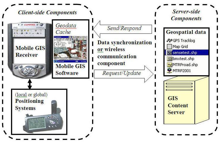
The architecture of mobile GIS is very similar to the Internet GIS. It follows the concepts of client/server architecture in traditional Internet GIS applications. The client-side mobile GIS components are the end-user machines which can display maps or provide analytical results of GIS operations. The server-side components provide comprehensive geospatial data and GIS operations based on the requested from the client-side components. Between the client and server, there are various types of communication networks (such as wired cable connections or wireless communications) to facilitate the exchanges of geodata and services between clients and servers. The following figure illustrates the six basic components of mobile GIS:
1. Positioning systems
2. Mobile GIS receivers
3. Mobile GIS software
4. Data synchronization/wireless communication component
5. Geospatial data
6. GIS content servers
The Architecture of Mobile GIS
Positioning Systems refer to the devices which can provide georeferenced coordinate information (X, Y, and Z-elevation) to mobile GIS receivers. There are two major systems, local positioning systems and global positioning systems (GPS). Local positioning systems rely on triangulation of the radio signals or cellular phone signals from multiple base stations in order to calculate the position of these devices. GPS use satellite signals to calculate the position of the GPS units. Sometime, mobile GIS applications may require both types of positioning systems in urban areas for generating better results.
Mobile GIS receivers are small-sized computers or terminals which can display maps and locational information for end-users. The hardware components of mobile GIS receivers include CPU, memory, storage devices, input/output connections, and display (screen) functions. Pocket PC, smart phone, tablet PC or PDAs are the most popular mobile GIS receivers. Sometime, notebook computers can become a mobile GIS receiver if they get connected with GPS and other mobile GIS components. However, most mobile GIS receivers require a very small size hardware device for their portability. The major differences between small mobile GIS receivers and traditional personal computer are smaller screen resolutions (240x300), limited storage space, and slower CPU speed (Wintges 2003). Some high-end mobile GIS receivers equipped with wireless communication devices which can be used for data exchanges and telecommunications between the receivers and the content servers. Otherwise, the mobile GIS receivers will rely on serial cables or USB cable to transfer data between the content servers and the handhold devices.
Mobile GIS software refers to the specialized GIS software packages for mobile GIS applications. Because of the limitations of mobile GIS receivers (smaller display units, limited storages, etc.), the design of mobile GIS software will need to focus on specific GIS operations (geocoding, address matching, spatial search, routing services, map display, etc.) rather than huge packages of comprehensive GIS functions. For example, the major design of LBS software is quite different from the functions provided in field-based GIS packages. Most mobile GIS software packages are lightweight, customizable, and can cope with positional systems (such as GPS tracking functions). Different mobile GIS software may require different operating systems (such as Windows CE or Palm OS).
Geospatial data are customized GIS layers or remotely sensed imagery for mobile GIS applications. Because of the limited storage space in mobile GIS receivers, most GIS data need to be compressed or clipped out from the original formats. Usually, the mobile GIS receivers will store the geospatial data in geodata cache , which is a temporary GIS storage space or a flash memory card. The customized dataset are downloaded and synchronized from the GIS content servers. One alternative approach is to utilize the wireless communication to access the large-size of GIS layers and remotely sensed imagery from the content server directly. The advantage of direct wireless access is that mobile GIS users can access most updated geospatial information from the content server without worrying about the complicated data synchronization process between the mobile GIS receivers and the content servers.
Data synchronization/wireless communication component are the communication mechanism to link the mobile GIS receivers and the GIS content servers. The linkages could be real-time wireless communication (via Wi-Fi or cellular phone signals) or cable-based data synchronization (via USB or serial ports). Both mechanisms should provide two way communications. For cable-based connection, the GIS content servers can send geodata to the receivers (stored in geodata cache) and the receiver can upload updated geodata back to the content server. For wireless communication, the mobile GIS receivers can request a specific service or maps from the GIS content server, and the server will respond the request by sending the new map to the receiver. To facilitate the two way communications, several middleware or data synchronization software (such as Microsoft ActiveSync or Web Services) are required for mobile GIS applications. If both mobile receivers and GIS content servers have networking capabilities, the Internet can become a very effective communication channels for mobile GIS applications.
GIS content servers are stand-alone GIS workstations or web-based servers which can provide geospatial data or map services for mobile GIS receivers. Most cable-based mobile GIS receiver will use a stand-alone GIS workstation for the content servers. Wireless-based mobile GIS receivers may require advanced web servers or wireless Internet map servers for accessing geospatial data. Sometime, one mobile GIS receiver can access multiple web-based servers at the same time to integrate multiple GIS layers. One GIS content server can also provide data and services to multiple mobile GIS receivers at once.
Home | Introduction | Mapping Tools | 3D Animation | Mobile GIS| Links
Any med
May 8, 2006
maps and information by acknowledging the map producers and the
Department of Geography, San Diego State University.