US STREET ADDRESS-TO-GIS COORDINATES CONVERSION TOOL
Convert Your U.S. Street Address into Geographic Latitude & Longitude Coordinates
Location data is often available in U.S. street address format. In order to make this data compatible for many GIS software applications, it is necessary to convert the street address into geographic latitude and longitude coordinates. Fortunately, there are many tools to do this. The procedure to convert the street addresses to latitude and longitude coordinates is called address geocoding. A simple online address geocoding tool is provided here.
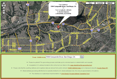
To use it, simply enter the street address of the U.S. location of interest and click the "Convert..." button. The result will be the complete address of the location, the latitude/longitude coordinates of the location in Decimal Degrees (DD) format, and a generalized map of the location. You can then use these latitude and longitude coordinates in your GIS software/map.
Acceptable formats for U.S. street addresses include
- 12345 Some St, Anytown, CA 92111
- 12345 Some Place N, Anytown, CA
- 12345 Some Ave, 60656
IMPORTANT: Note the locations of the "commas" in these examples.
In general, you MUST include the following 5 elements for successful geocoding:
- Street Number (e.g. 12345, 232, etc.)
- Street Name (1st, Sycamore, Washington, Main, etc.)
- Street Type (St, Ave, Blvd, Pl, etc.) &
(Optional) Street Direction (NE, S, N, etc.)
- Followed by a "Comma" (,)
- Then you have 3 OPTIONS:
-
Provide a City, State Abbreviation & 5-digit ZIP Code
-
Provide a City, State Abbreviation
-
Provide a 5-digit ZIP Code only
Brief Description of the Geographic Coordinate
(Latitude and Longitude) System
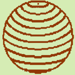
Geographic coordinates for latitude and
longitude represent the y-coordinate and x-coordinate,
respectively of a position on the sphere-like surface
we call earth.
Lines
(or "parallels") of latitude (the geographic "y-coordinate")
are circles of different size that encircle the entire earth. The largest circle is
at the equator and has a latitude of 0 Degrees. The
poles (latitudes 90° North and 90° South---or
90° and -90° without the hemisphere) are smaller circles
that shrink to a single point at each pole. To review, parallels of latitude
range from 90° North to 90° South (or 90° to
-90° without the hemisphere) and the equator is
at 0° latitude .
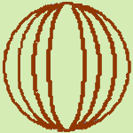
Lines
of longitude (or meridians) all cross the equator at
a right angle. Since the equator is a 360-degree circle,
the point where a meridian crosses the equator at a right angle is the
meridian's longitude in Degrees (the geographic "x-coordinate").
The meridian that passes through the Royal
Astronomical Observatory in Greenwich, England
was chosen long ago as 0 Degrees longitude. This line is
called the "Prime Meridian." Longitude is
measured from zero (at Greenwich) to 180° East
and 180° West (or 180° and -180° without
the hemisphere), and both of these 180-degree longitudes
share the same line, in the middle of the Pacific Ocean.
We call this imaginary line in the middle of the Pacific
the "International
Date Line." To review, meridians of longitude
range from 180° East to 180° West (or 180° to
-180° without the hemisphere); the "Prime
Meridian" that goes through Greenwich, England
is at 0° longitude; and the "International Date Line" is
at 180° East or West longitude.