GPS-TO-GIS COORDINATES
CONVERSION TOOL
Convert Your GPS Receiver Coordinates into a Format Acceptable to GIS Applications!
"Degrees/Minutes/Seconds" (DMS) Format
to "Decimal Degrees" (DD) Format Conversion Utility
(This utility also converts "Degrees and Decimal Minutes" Format to "Decimal Degrees" Format. Simply leave the the Seconds field blank.)
* Coordinates for the Southern Hempishphere should be negative.
** Coordinates for the Western Hempishphere should be negative.
Articles, publications, and GPS receivers often give geographic coordinates (Latitude and Longitude)
in "Degrees/Minutes/Seconds" (DMS) Format
(e.g. 123° 43' 52.12588" W
which is read, "123 Degrees, 43 Minutes, 52.12588 Seconds West Longitude")
or in "Degrees and Decimal Minutes" Format
(e.g. 123° 43.86876467' W
which is read, "123 Degrees, 43.86876467 Minutes West Longitude").
Unfortunately, when inputting data into a Geographic Information System (GIS) or other application, it is often necessary to convert to
"Decimal Degrees" (DD) Format
(e.g. -123.73114608°
which is read, "Negative 123.73114608 Degrees Longitude"). Also notice that this example uses a negative sign instead of using a hemisphere (N/S/E/W).
Incidentally, all three of these coordinate examples given here are the same longitude with accuracy to 8 decimal places. The simple and intuitive utility above assists you in this conversion process.
Brief Description of the Geographic Coordinate
(Latitude and Longitude) System
Geographic coordinates for latitude and
longitude represent the y-coordinate and x-coordinate,
respectively of a position on the sphere-like surface
we call earth.
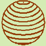
Lines
(or "parallels") of latitude (the geographic "y-coordinate")
are circles of different size that encircle the entire earth. The largest circle is
at the equator and has a latitude of 0 Degrees. The
poles (latitudes 90° North and 90° South---or
90° and -90° without the hemisphere) are smaller circles
that shrink to a single point at each pole. To review, parallels of latitude
range from 90° North to 90° South (or 90° to
-90° without the hemisphere) and the equator is
at 0° latitude .
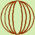
Lines
of longitude (or meridians) all cross the equator at
a right angle. Since the equator is a 360-degree circle,
the point where a meridian crosses the equator at a right angle is the
meridian's longitude in Degrees (the geographic "x-coordinate").
The meridian that passes through the Royal
Astronomical Observatory in Greenwich, England
was chosen long ago as 0 Degrees longitude. This line is
called the "Prime Meridian." Longitude is
measured from zero (at Greenwich) to 180° East
and 180° West (or 180° and -180° without
the hemisphere), and both of these 180-degree longitudes
share the same line, in the middle of the Pacific Ocean.
We call this imaginary line in the middle of the Pacific
the "International
Date Line." To review, meridians of longitude
range from 180° East to 180° West (or 180° to
-180° without the hemisphere); the "Prime
Meridian" that goes through Greenwich, England
is at 0° longitude; and the "International Date Line" is
at 180° East or West longitude.